Hardrock 2015
For the uninitiated Hardrock, is described as a run not necessarily a race, is a 100 mile loop through the San Juan Mountains in Colorado. As one of the premier courses in the ultra running world, being selected in the ballot and winning a coveted place for the chance to kiss the rock is very special. The course is describes as Wild and Tough and was set up as an homage to the hard rock miners who settled in these mountains. The course has 66,000 feet of elevation change and covers 11 peaks over 13,000 feet with an average elevation over 11,000 feet. The weather can, and does, alternate from hot sunshine to lightening and thunderstorms to heavy snow and with a 48 hour cut off everyone is out there long enough to experience most of those conditions numerous times. Described as a post-graduate race means all entrants must have completed a mountainous 100 mile race just to be placed in the lottery with 1,400 other ‘enthusiasts’.

Elevation profile
Summary
Although it had been melting fast over the previous weeks, some heavy May snowfall had left a great deal more snow high up than usual in the San Juan’s. The melt meant that the rivers were high and many more snow matches to cross. The snow was generally soft and we would all find ourselves post holing whilst crossing it. One of the runners this year counted 167 stream crossings, combined with the wet and boggy ground and snow meant that our feet were sodden the whole time. Looking after my feet was a priority from the outset as they would quickly deteriorate and brief admin stops were a worthwhile investment.
The weather can change so quickly and violently you can’t afford to leave anything out there, the paradox being that you always need to have something in reserve. I have learnt never go anywhere on the course without full rain gear, sunglasses, water, food, sun tan lotion. Where possible its best to eat low and absorb calories when you can.
There were plenty of storms this year but most of them passed though in less than an hour, which I think contributed to the high finishing rate this year. Having run the course before I don’t think that this race gets any easier, in fact knowing what is to come could be argued to make it tougher than just blind ignorance and optimism of a first attempt.
The climbs can take (me) anything from 1 to 5 hours and there is little respite on the downhills.
Finishing this race in this direction would make me a real hardrocker and gave me focus to finish. I knew I was capable but my fitness was not where I wanted it to be, but I was healthy and my mind was focused. I was fortunate having talented and experienced pacers and crew who sacrificed their precious time to support me and enjoy the ambience of the mountains. Cody (4th at the Bear 100 2015) and Beth (talented photographer) took the whole week to enjoy the mountains and support me in this. Ryan Smith (9th at UTMB 100 2015) and his wife Silke Koester (1st Bighorn 100 2015 and talented photographer) drove down from Boulder for the weekend. Crew Captain was Kea the border collie.
Longer version
I didn’t really expect to get through the ballot this time and was hosting a cheese and wine party on the evening of the draw making it tricky to keep up with the draw. Cody texted me midway through the evening and said I was in and that he was coming to pace me which was great news. Last year he was lined up to pace me but was taken to A&E in the middle of the night before the race. This time he was keen to keep our late night date.
This would be my third Hardrock and first in the C/W direction which gives a different dynamic to the race. I believe Karl Meltzer described this direction as up the ramps and down the steeps which theoretically is the slower direction and far more likely to trash your quads early on. Having run the race before doesn’t make it any easier, each time you know that the slightest mistake or issue could develop and prematurely stop your progress. The fear of failure helps motivate me in these challenges, the finish line is not a given, there is no easy finish. The closer the event gets the more frequent the surge of adrenaline and cold sweat breaks out as you remember the task ahead. As you reach what James Adams calls the event horizon (‘ – see his blog here) the butterflies really start to fly.
After being expert crew and really looking after me last year, Azusa unfortunately couldn’t join me this year due to lack of leave although she had promised to pace me the last 10 miles this year.
Training was steady but low mileage, low vert (20-30 mile weeks) and I seemed to regularly be hampered by late evenings at work. Living in Little Chalfont my stock hill for training could be run up and down in 2.5 minutes.
My training was consistent and steady and on the positive side it meant I was getting sufficient rest. I spent the preceeding 5 weeks before travelling in an altitude tent which seems to help, although it may be placebo. The first couple of weeks in the tent, as you increase the altitude, are tiring in itself.
I ran a very wet, windy and exposed (Might Contain Nuts) 40 miler in Wales in April which I figured would be good mental preparation. I also ran the V3K in Snowdonia (North Wales) which is on the Sky running circuit. It was only about 35 miles in distance but with about 4000m of gain taking in the awesome Crib Goch, it was prefect preparation.
I will apologise now for the number of photos (of me) but they paint a more comprehensive picture. Photos credits mainly Beth Draper and Silke Koester, with support from the boys Cody Draper and Ryan Smith. Other credits Gary Wang and me.

Pic fo the three category winners, 1st female, 1st male, 1st male aged 39 from Little Chalfont, UK.

Photo TA ; Kit ready to go. Spot tracker on shoulder.
I was staying with Lisa and Bill at Villa Dallvalle where I have stayed each trip and as usual they looked after me like one of the family. They were even up early the morning of the race to make breakfast and see us off and there taking photos at the finish too. It was good to have company for breakfast as Michael Chu had his full crew there too, I walked over to register at 0500 with Michael and then back for breakfast to avoid getting overly hyped. We walked back to the start line with about 2 minutes before the start.

Photo Beth; The front pack.
Start to Cunningham (Mile 0- 9.3; 0600 – 0827)
The morning started chilly and overcast with low cloud cover. Perfect weather from my perspective, I don’t enjoy running in the heat.
Dale finished the counted down with the familiar ‘get out of here’ and we were off. I knew that the first section was single track and to be free to run at my own pace so, knowing it wouldn’t last but would give me space I set off just behind the elite/top group. Well it would be the only time I saw them.

Photo Beth; Front runners.
It was great to see Cody and Beth at the top of the ski slope and then surprisingly again a couple of miles later at Aarasta gulch. From there it was straight up a long 4wd road before the trail peels off up to the top of Dives little Giant.

Photo Beth; At the bottom of the Silverton Ski slope.
After a while we rose about the (cloud) inversion and the views of the surrounding mountains was stunning. The night before it had rained down in Silverton and snowed higher up giving the tops of the mountains a light frosting. Leading up to the race the weather was cooler and wetter than my last couple of times in Silverton which seemed to result in less afternoon thunderstorm and more constant rain during the day and night. The night’s leading up to the race it rained solidly all night which did not bode well, but there seemed to be a partial weather window over the race weekend which looked promising.

Photo Beth; Still smiling, the climbing hadn’t started near Aarastra Gulch.
Was great to get to the top of Dives where there were a number of photographers and I could already see the leaders climbing out of Cunningham and up Green mountain ahead.

Photo Gary Wang; dropping fast into Cunningham.

Photo Beth; Cunningham Aid

Photo Gary Wang; Cunningham in the valley, looking towards Green Mountain, you can almost see the leaders to the right of the stream.
After a 2 hour chilly climb it was a relatively short 30 mins or so descent to the aid station at Cunningham where you splash across mineral creek and into a large number of spectators. Here was Beth, Cody who had now been joined by Silke and Ryan Rocky Mountain runners) and team Captain Kea (collie cross). After a quick sock change, a top up of water/tailwind it was straight off up Green mountain.

Photo Silke; Beth and Cody in foreground, Cunningham.

Photo Beth; The river was ankle-deep on most people.
Cunningham to Maggies (Mile 9.3 -15.4; 0827 -1040)
I was following Betsy Kalaymer who I knew would set a steady pace. Here I bumped into a few people and near the top was overtaken by Jamil Coury whom I thought would already be far ahead. Over the top of Green mountain and Stoney Pass and the legend that is Billy Simpson went steadily passed me on the way to finish #10 (aged 60).
It was noticeable how much faster either I was covering the ground or that much earlier in the race (not in pain) how much shorter and enjoyable the experience of these early sections felt in this direction.

Photo Beth ; Getting some thin air before the race at Maggies.

Photo Beth; Heading down towards Maggies during marking.

Photo Beth; Some actual running, obviously not during the race.
Maggies to Pole Creek (Mile 15.4 -19.7; 1040 – 1150)
It started to rain but fortunately the wind was from behind so although I got quite wet it wasn’t in my face. After half an hour or twenty mins the sun started to come out and it was pretty warm. I was running with Betsy and Ricky (from T-ride) who I ran close to all day.
The next thing the sun appeared for the relatively flat muddy and wet leg to Pole Creek. Arriving at the aid station I was welcomed again by the unfortunate lady (not sure of her name who I seen the last few times) who volunteered to patch my feet up in 2012.
A brief stop to grab some watermelon, coke and a potato and I was off. The next section was straight into a couple of stream crossing which felt good as the sun was warming up.
Pole Creek to Sherman (Mile 19.7 – 28.8; 1150 – 1412)
Previous years this section felt endless so I knew to be patient even if I was likely to be moving faster due to it being far earlier in the race.

Looking ahead to the climb before the long drop into Sherman.
Four of us started the long descent together, it started to rain with some heavy rain clouds being blown across the valley in front of us, we were lucky to only receive a sprinkling. On the decent our group traded places and we were joined by veteran Howie Stern. I had already decided to take my time to refuel and admin my feet (although not too long), in the aid stations.

Photo Silke; Kea hunting for marmots
I wasn’t expecting to see anyone at Sherman as it tricky to access via the 4wd Cinnamon Pass. But as we ran across the last stream crossing I heard the whoops from Ryan and Silke and support team captain Kea.

Photo Silke; Kea and Ryan meeting me at Sherman
My feet were feeling a little sore after being wet all morning so I took my shoes and socks off to dry them out and caked on the hydropel. I knew already that eating low would be beneficial and Handies was not far ahead so I downed a bowl of chicken soup with Silke and Ryan grabbing my drop bag and generally looking after me. Megan (Irunfar) came in just after me and decided she couldn’t her soup so I had her’s too. I definitely had a number of people pass me but 30 miles in and with Handies looming I wanted to regroup and let my stomach digest some calories whilst I was relatively low.

Photo Silke; Ryan and Kea looking after me as I try to dry my feet in Sherman.
Sherman to Burrows (Mile 28.8 – 32.6; 1430 – 1526)
It was pretty hot and exposed on the road but due to recent rains wasn’t too dusty although the road was busy with 4wd vehicles continuously passing.
Arrived in good time at Burrows, great to see Andrew Barney, briefly stop for some watermelon before starting the long slow climb up Handies in the hot sun.
Burrows to Grouse (Handies) (Mile 32.6 – 42.2; 1527 – 1914)
The weather started clear hot and sunny. It was slow progress but I was close to Mike Erhert (who has run over 4,000m W-E across the US planting flags ever mile for every US life lost in Iraq and 2000 miles N-S doing the same for the conflict in Afghan see here (a humble guy). At one point he stopped and asked for a hand finding his contact lens lost at the back of his eye, I can’t imagine what a pain it would have been to if we hadn’t been able to find it.

Photo TA; Handies taken during course marking
This felt long and slow and I could see runners ahead as they summited, on the skyline far ahead. Again there was about 4 of us who were climbing closely and often changing places.

Photo TA; Course marking towards the top of Handies, that’s Charlie (course designer/planner) with the poles, picking the direct route.
As we arrived at 1000 feet below the summit a storm blew in, fortunately it was a snow storm, whilst cold and miserable, it would have been worse if it had been wet too. I pulled my jacket out but didn’t bother with gloves/hat/spare layer, from my bag which was probably a poor choice. Actually it was a very poor choice, I was freezing in the snow blizzard, hoping that the thunder-storm wouldn’t develop into a lighting storm too. But knew once I was over the summit and we starting dropping into American basin and away from the exposed summit ridge, we would be running out of the wind too. By the time we had dropped to the basin the sun appeared again to make the climb out of the basin hard work. This was now turning into ‘Type 2 fun’ (not necessarily immediate fun but the sort of thing which is fun to think back on later).

Photo TA; Awesome flowers looking towards American basin.
From the Grouse/American saddle it was a long drop/cruise all the way down to Grouse, although my stomach was uncomfortable by this point and wasn’t able to break in to a jog much.

Photo Beth; arriving at Grouse
Finally Grouse, I was doing my best not to look at my watch but was vaguely aware that I was hoping to hit Grouse before dark and ideally 7-9 PM. This was mentally a big tick, the highest point on the course was ticked off before dark, metaphorically it was all downhill from here…

Photo Ryan; Arriving into Grouse aid, Engineer in the background
I arrived about 7.15 and my crew rushed into action looking after me, change of shoes and socks, vest to t-shirt but I hadn’t waterproofed my drop bag well and any spare cloths had got wet. I should mention at this point the normal tracking system on the HR website had crashed. This year HR had decided to trial a number of GPS trackers (for accuracy and safety) which I had elected to wear. It mean that my crew didn’t waste any time waiting aimless and they had an idea, within about 10 mins, of when I would arrive at each CP which was great as most others were effectively working blind. Hopefully everyone will carry one of these next year.

Photo Ryan; Looking and feeling great at Grouce Gulch…
Grouse to Engineer (Mile 42.2- 48.7; 1934 – 2151)
Some soup and a cheese cassadia to go, Silke (winner of recent Bighorn 100) and I headed at a steady walk up Engineer road. I was slow and declined to pick up pace on potentially runnable stretches, my stomach wasn’t feeling up to it. We were treated to a spectacular sunset.

Photo Ryan; Silke and I heading up Engineer.
Just after we crested the top of ‘Oh point’ we turned on the head torches. The top part was wet and slippery and I stacked it a couple of times, I will be impressed by anyone (with 45 miles in their legs) who managed to stay on their feet here. The night was still and calm at this point and remarkably pleasant. Engineer appears out of nowhere from both directions and we made it to the CP in good time. The tent and fire appeared suddenly as we hit treeline. I had already asked Silke not to let me near the fire, a fire after dark is like a siren call. A fire at an aid station amplifies the sirens calls to stop and rest, but there is only danger there. We grabbed a handful of saltines to settle the stomach, and we were off.
Engineer to Ouray (Mile 48.7 – 56.6; 2156- 0015)
The next section is single track almost all of the way down to Ouray, the lower parts being along high and exposed cliffs which are spectacular during the day. At night our head torches disappear into the abyss.
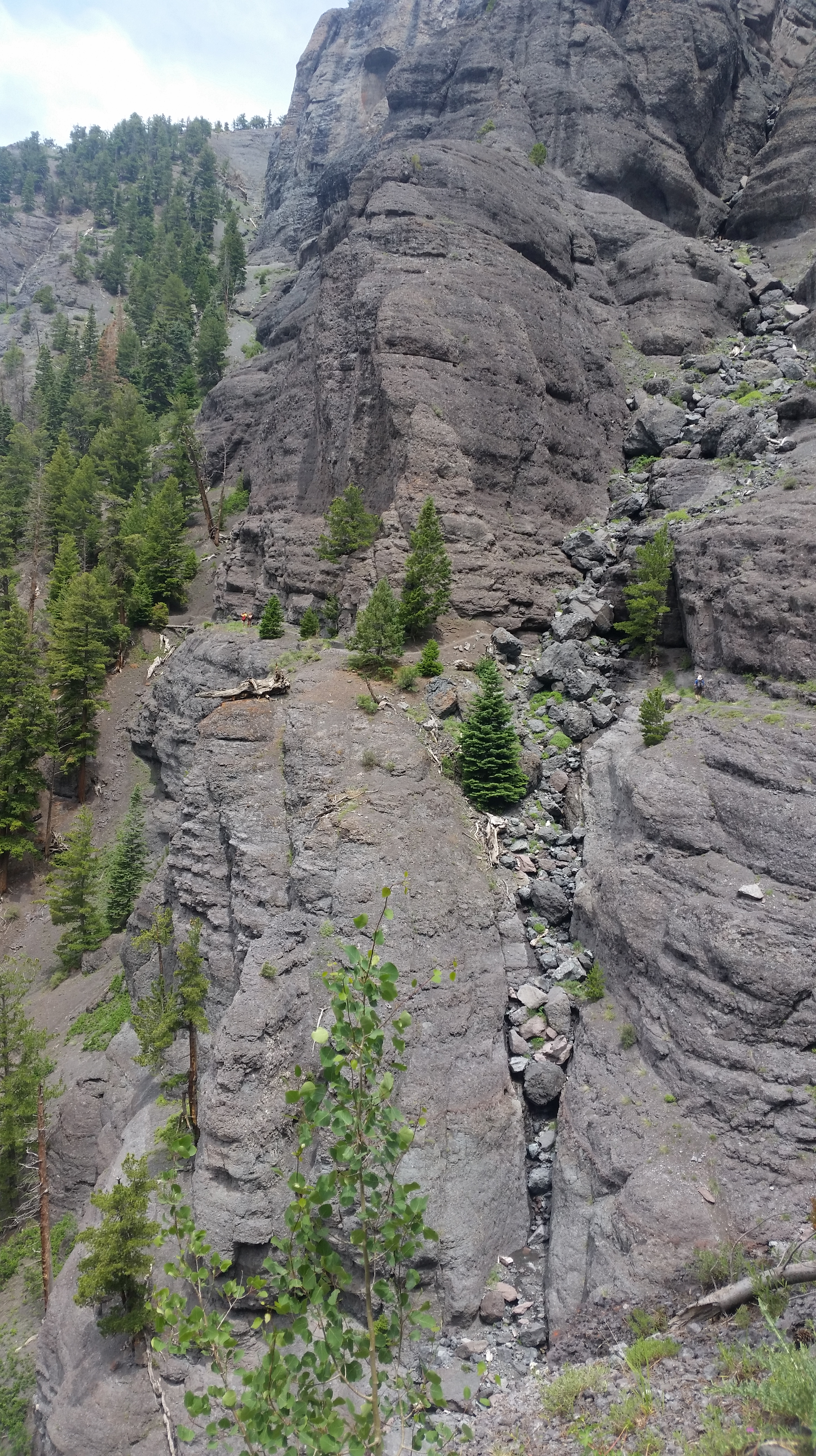
Bear Creek Ouray section during the day. If you can locate the people standing on the ledge, it will give the photo perspective.
There were a number of stream crossing on this part one or two being very loud and intimidating. On the horizon a silent lightning storm lit the sky. We stopped to check out the stars. Eventually the lights of Ouray were a welcome sight and the temperature increased as we dropped into the valley. Hitting the aid station just after midnight everything was feeling pretty good. My head torch had flashed a few times after only 3 hours which was worrying even though I had spare. Silke selflessly handed me her battery though.
Ouray aid station was a flood of activity and I was immediately guided to a seat with a blanket and warm jacket thrown over me. It was a quick change of socks and shoes, some pizza and then I was off with Cody heading up. Cody had 3 years of pent up excitement which was infectious and staved off any thought of rest.
Ouray to Governor Basin (Mile 56.6 – 64.5; 0039 – 0319)
Camp Bird Road feels endless, at an angle that is rarely anything other than steep. Again we made sure we stopped to appreciate the abundance of the stars filling the sky and marvel again at the creators handiwork. As a precaution we also decided to only use Cody’s head torch to preserve my light battery.
Having scouted the turn off earlier in the week we were not worried about missing the junction and made the aid station in good time. We heard here we had recently missed a rain shower but now sometime around 3am it was starting to feel very cold. I started to feel ropey when we stopped and the potato soup seemed to make things worse although I managed to avoid the allure of the heated tent. Concerned that the temperature would only get colder I donned most of my clothes including fleece hat, waterproof outer gloves and rain trousers. The aid station staff were surprising chirpy at this time of morning although I started to retreat inside my head at this point, only focused on the summit. The wind was picking up and it would only get colder.
Governor to Virginuis (Krogers Canteen) (Mile 64.5 – 67.8; 0324 – 0507)
Immediately after the aid station were another couple of fast and almost knee-deep streams which I didn’t particular appreciate as I was still cold from having stopped. From here it was a long, cold, dark plod towards Krogers canteen. Before we arrived at Virginius and the top 3 no. pitches I started puking, which in itself wasn’t too bad. The track gave way to snow and ice which meant concentrating, harder than usual, on staying upright.

Photo anon; Last pitch to the top of Virginius and Krogers Canteen in the cleft at the top. We hit this around 0430, all we could see was headlights ahead.
As we climbed the lights of runners ahead of us started to climb the last pitches to the pass, whilst generally not seeming to move at all. Dawn was almost breaking as Cody and I crested Kroger’s, but I was keen not to linger still. As always at Krogers I felt decidedly rough and despite the exuberant welcome committee and the energy Roch Horton’s dedicated team were exuding I wanted to move.
Virginius to Telluride (Mile 67.8 – 72.8; 0510 – 0655)
We dropped fast although my stomach was delicate and I couldn’t run. Having stopped a number of times of the descent to empty my guts, Howie Stern and his pacer Katie De Splinter continued to leap-frog us.
The trail here is steep and we were soon in Telluride, meeting Silke, Ryan and Kea at the trailhead and we all headed to the aid station where Beth awaited with breakfast. We arrived just before 0700 (25 hours in). The new day was fresh and sunny.
Telluride to Chapman (72.8 – 82.1; 0712 – 1142)
As we left T-ride Leah Finn and her pacer Jenn Shelton arrived at the aid station, I had ‘run’ with Leah in the 2012 HR so was good to see a familiar face. I was feeling more energised at this point although the trial was wide and flat here. I had been thinking about this climb with some trepidation as I knew it was the last really large one. The scenery up the Waasach basin is incredible and continually changing. We crossed numerous streams but as we approached the snow line a blizzard hit. We could have kept going but decided to hunker down for 5 minutes to miss the worst of it.

Any fool can be uncomfortable…
At this point Billy Simpson and his pacer flew past focused on one thing. The storm intensified with lighting strikes to the nearby ridge line. This is the point where there was no discernible path (KJ had managed to get lost here the previous night). The snow covered everything and it was almost impossible to locate any markers. We knew generally where we were heading but was good to have Billy not far ahead to keep an eye on too.

Photo Cody; Looking from the top of Oscars towards Grant Swamp Pass in the distance.
As we hit the ridge the sun was out and became very hot again, this relatively small section was treacherous as the ‘path’ traversed the ridge line and one miss step and we would have slipped 50 ft or more, not so much dangerous as the snow was soft, deep and melting and would have been incredibly hard to regain the path. Over the top of Oscars and the valley and Grant Swamp pass (4 miles away) opened up in front of us. The top of the trail on Oscars is large ‘ankle twisting’ boulders so I concentrated on keeping solid footing. My stomach was still off so even jogging was not really on the menu.

Photo Cody; Aspen trees near Chapman
Finally through the aspen forest and into Chapman. Everyone was keeping an eye on the storms which continues to circle. Much to our surprise Beth had hiked some way in to this aid station humping drop bags and provisions and was straight away looking after us both. The end was almost in sight… albeit 8 hours away…
Chapman to KT (Mile 82.1- 89.1; 1200 -1509)

Heading up Grant Swamp Pass, two steps forwards and four steps backwards.
It was starting to rain as we left but we were fortunate and didn’t experience the storm. In fact the sun came out and baked us periodically on the climb.

Photo Cody; Climbing Grant Swamp Pass, looking back towards Chapman and Oscars.
Grant Swamp is steep scree and whilst Cody bounded up this section and decided to film me heading up, from my perspective it was a slow slog with 100% concentration on not sliding back to where I started. It started to rain/snow on this section and we wasted no time popping over the top and speeding down towards Island lake.

Photo Silke; Near the top of Grant Swamp pass, this is part of the course…

Joel Zucker memorial overlooking Island lake, during the course marking, which is still covered in ice.
We saw Kea first who was taking Silke and a friend out for a hike. It was great to see them and brought a spike of positivity.

Photo Silke; Cody and I descending from Grant Swamp Pass just before the trail turns off and crosses the river.
Not far to go, over the river and then along the Kam traverse. This section was warm and sunny and we were pretty warm once we hit the aid station.
KT to Putnam (Mile 89.1 – 94.7; 1513 -1800)
Ryan was there ready to go and with a quick goodbye to Cody who had done a sterling job over the last 35-40 miles and 16-17 hours and kept me trucking along.

Photo Gary Wang; Cody and I on the Kamm Traverse, approaching the aid Station.
Ryan was in a great mood having waited over 30 hours to join me and was doing his best to motivate me, although at this point I had one speed. The main thing was RFM (Relentless forward motion). We started the climb in hot sun, balancing the fact that I was nearly there with the fact that the finish was still a tantalising 4 or more hours away.

Photo Ryan; Climbing back to collect my poles which were stuck in the snow as I slid down.
Across the saddle my feet had been feeling sore and wet for a while so I stopped briefly to change socks and dry them out. Then it was up the short and steep off trail final climb to the ridge. My aim (for the last two attempts) was to finish in the light and it was still on.

Photo from course marking. Camera looking down towards Putnam aid station.
You can almost see Silverton from the top of the final climb and the finish was in sight. We flew (also known as walking) past the aid station calling out a hello as passed.
Putnam basin to Silverton (Mile 94.7 – 100.5; 1800 – 1944)
Parts of the trail here were rocky and I concentrated hard not to twist an ankle. I was still trying to run where possible (my legs were fine) but my stomach wasn’t having it. This is one of the 4 areas known as bear Creek on the course (inventive lot the American’s) and where I had seen a bear during the marking. To make things more interesting there was fresh bear scat on the trail meaning this was clearly aptly named.
As we hit the Mineral Creek, Ricky from T-ride and his pacer Tina Lewis caught us, which gave me a kick up the proverbial. As a rule I am not competitive, however, with 2 miles of relative flat to go I didn’t want to be overtaken if I could help it. Mineral Creek was flowing fast and high which gave some relief to the legs and came up to my shorts, fortunately after debate during the course marking Charlie had relented and put up a rope crossing. Without it the stream would have been verging on dangerous especially on tired legs. Cody and Beth were there cheering too, but at this point I was focused on kissing the rock. Ryan was still encouraging me, desperately trying to wheedle out any final burst of ‘speed/slow jog’. From there I managed to ignore my stomach issues and jog out the last few miles. As we rounded the last bend we could see the town below us.

Photo Silke. Home.

Photo by Silke. finishing straight, flanked by the team.
A rainstorm threatened but instead of intensifying it moved away and we were left with a stunning rainbow. As Ryan and I turned downhill in front of the Christ of the Mines shrine, we could see Kea and Silke waiting. As we approached they joined us. A block from the finish Cody and Beth joined us too and it was a great moment to have the whole team there to enjoy the finish. The final turn and there was the rock.

The team! From L to R. Silke, Ryan, Kea, Moi, Cody and Beth

It was great to see Dale (RD) in the light for a change. I felt tired mentally but my body (mainly because my stomach had slowed me down) was in good shape. I stayed and chatted to the crew and Warren Muldoon a friend who I originally met in a race in Namibia who had unfortunately DNF’d earlier that day. Beth and Cody had practically been up since the start too and were off to their tent. Ryan, Silke and Kea had other friends still to support.

Photo Gary Wang shot just before I kissed the rock.
I headed back for a shower planning on returning to watch other finishers. The reality was I passed out on the bed after a quick shower and woke up in the light thinking it was a few minutes later. In reality it was the following morning.
The awards ceremony was typically uplifting and embracing. After spending hours promising myself ‘never again’ …I think it would be rude to not throw my hat in for next year. Azusa and my family have lost any pretence of sympathy as ‘I do this to myself’ so ‘you wanted this so just you suck it up Princess’.
I feel extremely blessed to be drawn in the lottery, physically able and to have so much support, Azusa (who was stuck at home working), family, friends and great crew as well as the amazing Hardrock volunteers and board who spend so much time into making the event run so fluidly.
This event is like no other. There are few runners who could contemplate racing at events like this. Almost everyone is solely focused on getting to the finish and enjoying the ambiance and wilderness of the mountains. This means that supporters and other runners are incredibly supportive, which is a real boost, the race as such is in each competitors mind rather than against each other. Unfortunately after a few miles anything beyond a grunt of acknowledgement is considered too much effort.
Sunday afternoon after the awards ceremony I packed and headed out for a mid-afternoon Pizza in Avalanche. I ended up sitting next to K-dawg who was hanging out with a friend. As they were leaving we congratulated ourselves on both being real hard rockers now (finishing the course in both directions). We high fived, fist pumped and hugged it out before heading off. (note some of that may only have occurred in my mind). Here is the go pro video from the race https://youtu.be/55-OcQQ_wv8
Kit choice; Shoes, inov8 x talon 190, trailroc 235; pack s-lab sense ultra set (3 litre) which carried at all times, waterproof mitten outers, Saloman bonatti jacket and trousers, goretex/fleece hat, sunglasses, one long sleeved top, hydropel, Petzel Nao headtorch and spare batteries, black diamond z poles; I also carried the spot GPS locator on my shoulder strap.
Final notes;I am not sponsored and all of the kit is my own choice, however, I fortunate to be on the Centurion Running team.
Photo credits, Silke Koester, Ryan Smith, Cody and Beth Draper, Gary Wang (I have purchased his photos that are shown here).

I REALLY enjoyed reading your hardrock last year and I’ve waited for this year’s- a great write up with lovely pics and this year, a movie at the end-bloody brilliant!!
For me this was an enthralling 30 mins; of seeing someone run really well through beautiful beautiful country.
Enjoy the next one and bring us along too, please
LikeLike
Mark
Thanks for the kind comments. I hadn’t acually meant to publish this last week. I have updated some bits. Glad you enjoyed it. T
LikeLike
Fantastic write up, Tim. I thoroughly enjoyed reading it and reliving the whole experience- and learning a few more bits I didn’t know. 😉 I am super impressed with your run. Congratulations on such a solid finish. And thanks for giving us such a good excuse for an amazing vacay.
LikeLike
Tim,
Awesome report my friend!! Great pics and it brought back many memories for me. It was great sharing the trail with you and I will forever be grateful to you for saving my eyesight when my contact was out of place going up Handies!
Hope your future travels are just as enjoyable !!!!!!
LikeLike
Thanks Mike it was greta to spend time with you on the course. Glad we found the lens, that could have been a pain T
LikeLike
Hey amazing achievement . Love the photos !
LikeLike
Very proud of you x
LikeLike
Wow! Great write-up and brilliant pics of an incredible event. Well done seems inadequate…
LikeLike
You legend!
LikeLike
Quite something. Quite something!
LikeLike
Thanks for writing about your experience. I am curious…if you were “only” running 20-30 miles per week, how do you manage to train for all the elevation gain/loss?
I’ve done 4 100s, and normally can’t get much over 40-45 miles per week or my body falls apart. I want to do HR, but not sure how to get ready to climb and descend so much.
Just curious as to your train up — you obviously did well finishing in 37 hours!
Thanks
Mike
LikeLike
Mike, thanks for your note and sorry for the slow response. I did sleep in an altitude tent for the elevation before the race and just included as many hills as possible, although thats not many around here. My legs actually felt ok at the end of the race as you are moving slowly most of the time too. Maybe some specific leg strengthen excercises, such as lunges and squats, but IMO, it is better to turn up fit strong and rested and not be too concerned with massive milage. I have always turned up at least 10 -14 days out from the race to join the HR trailmarking which is great for acclilmatisation and getting some hills work done at a slow pace too. T
LikeLike
Thanks and no worries on the delay.
Interesting approach and one I will keep in mind. And probably a good idea to invest a little more time to acclimate, work hills and see the course as you are marking it! I assume getting into HR will take some time, so when I get back from overseas I hope to hit the San Juan Soliste or maybe the Ouray 50 to get accustomed to the SJ’s.
Last question…how did you approach your first successful go at HR? Was it lower mileage as well?
When I finished Bear in 2014, I trained hills exclusively on the treadmill since I was deployed…so I am going to look to work in some of that as well.
Thanks again
LikeLike
Hey Mike thanks I will drop you a separate email T
LikeLike